
Dating an Early Map of Swansborough, North Carolina, with Matches to Initials of Lot Owners or Occupants
A message from the author:
Attached is another intended donation to the GFO.
As written, the appendix complements the report, and the report provides background and context for the appendix.
The GFO has my permission to post it online and/or to make complete copies, and individuals may make single copies for their personal use.
Stephen Wayne Turner
From the attached article:
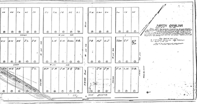
“In May 2017 I found on a website entitled Swansboro, North Carolina History a map of the Onslow County town (incorporated as Swansborough in 1783) showing the original 48-lot town grid (hereinafter referred to as the map). All but three of the lots were labeled, mostly with initials of owners or apparently in some cases, of occupants. It was apparently a 1917 hand copy from an 1840 hand copy of an original map dated 20 Oct 1772. Being familiar with many of the lot owners in the later 1700s from my work with tax lists it appeared to me the initials must have been applied within that era but reflected a somewhat later time than 1772. As it showed initials of particular interest to me on a certain lot also of particular interest, I wanted to try to date the time to which the initials pertained.”